100010011111001011111010110010
Produktuppdateringar

VAD ÄR NYTT

De senaste funktionerna, förbättringarna och rättningarna i Borebase, med en närmare titt på det som betyder något.

v2.2.25

Clearer Estonian and Finnish throughout Borebase

  • Förbättrat

    Reviewed Estonian and Finnish terminology across the website, application, technical guides and release history. Import dialogs, metadata and export labels now use the selected language, and website links preserve it when opening guides or signing in.

  • Rättat

    Exported drawings keep dates and numeric text intact when geometry is rounded. Finnish dates no longer lose digits during export.
v2.2.24

Map markers restored

  • Rättat

    Object markers are visible again on project maps and the cross-section map, including after changing marker size. Fixed the XML error that could cover the map in Firefox.

v2.2.23

Link dynamic probing tests to boreholes

  • Rättat

    The related borehole selector for dynamic probing now lists the project boreholes and displays an existing link correctly.

v2.2.22

Half the download to open a borehole, and nothing fetched for a tab you did not open

  • Förbättrat

    Borehole and project pages download only the tab you are looking at

    Opening a borehole used to download the code for every tab at once, including the Excel export and the formula renderer, whether or not you went there. Each tab now arrives the first time you open it, and Excel export loads on the click. The borehole page is 48% smaller on the wire, the project page 30%, and the first screen after login 15% smaller. On a slow or metered connection the browser also stops fetching the next page in the background.

  • Förbättrat

    Reference lists are remembered for an hour

    Soil materials, rock types, object types and the other reference lists were downloaded again on every page. The browser now keeps them for an hour, so a second borehole opens without re-fetching them.

v2.2.21

Exports no longer cut off at 20,000 points

  • Rättat

    CPT, SPT and DP exports (CSV, XLSX, DXF), recalculation and stratigraphy generation now use every reading in a test. A long test past 20,000 points used to be silently cut off.

v2.2.20

Status and map export messages in your language

  • Rättat

    The message shown after changing a project status, and the messages shown while exporting the map to PDF, now appear in the interface language. They were always in English.

v2.2.19

Borehole links stick on create, depth scale in project units, DP export says Yes or No

  • Rättat

    Linking a CPT or SPT test to a borehole while creating it now sticks. The link was dropped on creation and only appeared after the test was saved a second time.

  • Rättat

    The dynamic penetration CSV and Excel export writes Yes or No in the Refusal column for every measurement. A measurement without refusal used to leave the cell empty, which looked the same as a value that was never entered. The Note column header now carries the same (-) mark as the other unitless columns.

  • Rättat

    On a project measured in feet, the depth scale next to the stratigraphy log and the related CPT log, and the depth heading on the CPT stratigraphy tab, now show feet. They printed the stored metres while the rest of the page showed feet, so a 10 ft layer read as 3.

v2.2.18

Geophysics surveys show their type and unit again

  • Rättat

    A geophysics survey now shows its survey type, the unit of its values and the default colour on the survey card and in the detail view. These were read from the wrong place and came out blank.

  • Rättat

    Running the processing pipeline on a survey reports how many points it processed. The message used to read "Processed undefined points".

v2.2.17

Duplicating an object now copies all of it

  • Förbättrat

    Duplicating an object copies everything it holds in one step: the borehole construction and all layer types, including technogenic and organic layers, plus SPT and dynamic penetration data, none of which were copied before. The copy is now made in a single operation, so a duplicate either appears complete or is not created at all - there is no longer a half-finished object left behind if something goes wrong along the way.

v2.2.16

Batch export draws the same picture as a single export

  • Rättat

    Batch export now renders geophysics graphs and CPT layer colours exactly like the single-object export. Geophysics columns came out empty and CPT layers lost their classification colours when several objects were exported at once.

v2.2.15

GeoJSON export for GIS

  • Nytt

    Project objects can be exported as GeoJSON from the Objects tab, next to CSV and Excel. Every object becomes a point with its name, type, status, elevation and depth, ready to open in QGIS or ArcGIS. Coordinates are WGS84 and lengths are metres, as the format requires; objects without a location are included without a point.

v2.2.14

Updated subscription pricing

  • Förbättrat

    New subscriptions now use consistent per-user pricing on the public pricing page and at checkout: €79 monthly or €790 annually. Existing active subscriptions keep the price already attached in Stripe.

v2.2.13

Live updates keep working in a tab left open

  • Rättat

    A tab left open for a long time no longer stops receiving live updates. The connection renews the session on its own and waits before retrying, instead of going quiet after a maintenance restart or once the login has expired.

v2.2.12

Compact project and object navigation

  • Förbättrat

    Collapsing project and object headers keeps the back button, name and all tabs in a compact row. Tabs are centered, with the expand and collapse control at the right edge. The expanded project header gives long names more space and uses less vertical padding. The main navigation bar is also more compact. Project and object pages remember the same header state within a browser tab; tutorials temporarily reveal header controls when needed.

  • Förbättrat

    Project and object tabs now use consistent compact white toolbars with smaller controls. The planner uses the available workspace without surrounding cards, with 8px of padding around Timeline and Board.

  • Nytt

    Connect water levels across a cross-section and adjust the bends between boreholes by dragging, while measured levels and labels stay fixed. Connected curves replace the separate horizontal markers. Bends are saved with the section and included in PDF/DXF exports.

  • Rättat

    Cross-section symbol overlays remain visible when column width is zero. Samples and water levels keep a readable width, including in exports.

  • Rättat

    The month and date scale no longer overlaps task details or the new-task panel in the project timeline.

v2.2.11

Task descriptions and assignees in the project plan

  • Nytt

    Create tasks with a description and assign multiple company members. Task cards show email-initial avatars, and a shared person filter works in both Board and Timeline, including unassigned tasks.

  • Förbättrat

    Task and object statuses on the board are now colour-coded pills. New tasks are saved only after confirming the form, and unsuccessful saves keep the entered details.

  • Rättat

    Task creation and editing panels stay below the project header and plan toolbar, with their own scrolling on smaller screens.

v2.2.10

Clearer borehole and DPT icons

  • Förbättrat

    Dynamic probing (DPT) now uses a weight-and-cone icon in project summaries, search, object filters, object creation, the export panel and default map markers, including map PDF exports.

  • Förbättrat

    Boreholes use a clearer drill-bit icon in project summaries, search, object filters, object creation and the export panel. The completed-object indicator uses the same drill bit, and borehole and DPT icons now match the size of CPT and SPT in the project header.

v2.2.9

Explicit geological interpretation in cross-sections

  • Nytt

    Connect one interval to a contiguous group of intervals as a named geological unit, without changing the original borehole observations. Choose the material on either side or show a lateral transition with a straight or broken contact. A selected layer now offers an explicit pinch-out action.

  • Förbättrat

    Geological fills are opaque, and column width can be set to zero while layers remain available for selection and connections. Compatible interpreted contacts can be joined to close a gap, then detached while preserving their shape. Observed borehole depths stay fixed.

  • Rättat

    Surface geometry no longer changes with drawing scale or column width. Shared-contact edits prevent inverted layers, and a first described interval below ground no longer fills an unlogged gap. Removed layers and data-loading failures are reported explicitly instead of silently showing different or missing geology.

  • Rättat

    PDF exports exclude selection outlines, editing handles, previews and temporary tool-only surface lines. Legends reflect visible materials and distinguish the two sides of a named material transition. Surface and fault editing handles remain accessible outside the geological clipping area.

v2.2.8

CPT layer averages and planning board layout

  • Rättat

    CPT stratigraphy now shows layer averages from the current measurements, including for manually created layers. Values update after changes to measurements or layer depths, and CSV and Excel exports use the same averages.

  • Förbättrat

    Planning board columns now evenly fill the available width, with horizontal scrolling in narrow windows. Switching between the board and timeline keeps the main toolbar steady. Period controls sit inside the timeline, and its colour legend opens only when needed.

v2.2.7

Signing in no longer bounces you back to the login screen

  • Rättat

    "Session revoked" straight after a correct password

    Every so often a correct email and password was accepted and then, a blink later, threw you back to the login screen with "Session revoked - please login again". Nothing was wrong with the account: the first page the app asked for could be answered by a server that had not yet been told about the sign-in that had just happened. The same timing could make a project or a borehole you had just created look missing for an instant. Each request now finishes its work before its answer leaves, so what you get back always reflects what you just did.

v2.2.6

Guests can find their projects in the search box

  • Rättat

    Search now finds the projects shared with a guest

    A guest invited to one of your projects got "no projects available" from the search box in the top bar, however they typed the name. The box was looking for the projects of a company, and a guest belongs to none, so it never searched at all. It now looks through exactly the projects that have been shared with them, and their objects.

v2.2.5

Importing a CPT or SPT file is several times faster

  • Förbättrat

    Importing measurements from a CSV file no longer crawls on large files

    Saving imported measurements asked the database about every single row separately. A 1748-row CPT file meant more than three thousand round trips, and the progress bar sat there for two and a half seconds. The rows are now looked up in one go, and the same file imports in under half a second. The result is identical: rows you already had are updated, new ones are added.

v2.2.4

Every page you open asks the database four fewer questions

  • Förbättrat

    Who you are is looked up once, not on every request

    Before serving anything, the app checked four things about you in the database: that your session is still valid, which companies you belong to, whether you are a platform administrator, and which shared projects you can read. It did that on every single request, so a page making a dozen calls asked the same four questions a dozen times. Those answers are now remembered for a minute and refreshed the moment any of them changes, which takes two thirds of the database work off a typical page. Logging out, a changed role or a withdrawn share still take effect immediately.

v2.2.3

Every page opens faster, and switching language is one download instead of eight

  • Förbättrat

    Pages no longer wait for a search you have not opened

    The search box in the top bar used to load every object in every one of your projects the moment any page opened, whether or not you went near it. On an account with 25 projects that was 25 extra requests on every single page. It now loads that list the first time you open the search, and remembers it, so closing and reopening the box costs nothing. Project and borehole pages open several times faster as a result.

  • Förbättrat

    Switching language downloads one file instead of eight

    Each language was split across eight separate translation files that were all fetched at once when you switched. They are now packed into one file per language, which is both a single request and smaller overall, so the new language appears sooner.

v2.2.2

Faster page loads, and exports that no longer slow down everyone else

  • Förbättrat

    The app loads noticeably faster, especially on your first visit

    The sign-in and account settings screens now download up to 80% less code than before, and every other page only loads the map engine and language files it actually needs instead of all of them upfront. The difference is most noticeable on a slow or unstable connection.

  • Förbättrat

    A large map or report export no longer freezes the app for other users

    Generating a map export used to briefly block the server for everyone while it rendered. Exports now run alongside normal traffic, so a colleague running a large export no longer makes your page stall.

v2.2.1

The borehole schematic, the section toolbar and your account settings

  • Rättat

    Narrow windows reflow without breaking the workspace

    The CPT Advanced tab now responds to the width actually available to it, so charts and settings stack as soon as they need to rather than after an unrelated browser breakpoint. Below 1024 px the desktop recommendation appears dynamically over a blurred backdrop throughout the app, and can be dismissed for the current narrow-width session.

  • Rättat

    Coordinate and cross-section panels stay attached to their controls

    An EPSG list opening upward now sits directly against its field even when the list is shorter than its maximum height. In Cross-section, the Cross-sections, Objects and Elements groups share all available sidebar height and no longer end in clipped lists or an unused blank area when groups are collapsed.

  • Förbättrat

    Cross-section visibility covers every object type

    Object-name visibility can now be set independently for boreholes, CPT, SPT, geophysics and DPT instead of choosing only boreholes or CPT. Layer-name choices show the types that really carry stratigraphy, and the panel points to the per-object controls used for CPT, SPT and DPT graph overlays.

  • Rättat

    DXF sections open on the PDF-sized sheet without oversized files

    A DXF now opens directly on its plotted Cross-section sheet at the selected A4, A3, Letter or custom dimensions. The measured geology stays in model space while the frame, title block and company logo stay on paper. Repeated hatch curves, sand grains and gravel rings are stored as compact CAD paths instead of tens of thousands of tiny line objects, so large sections remain practical to download and open without losing the pattern shapes seen in the PDF.

  • Rättat

    Screens, filter packs and grout are drawn the right size again

    When a borehole was recorded narrower than the casing inside it, the Construction tab worked its scale out from the casing and then drew the grout and filter pack against a wall further out than that, so the schematic spilled over the stratigraphy columns beside it. A casing with no recorded diameter was counted as having no width and then drawn at a default one, which on the training water-supply well made the casing three hundred times wider than the drawing holding it. The tab and the PDF column now build the same drawing from the same measurements, and the drawing is always scaled by what actually reaches the page.

  • Rättat

    The training projects describe their wells correctly

    The demo water-supply well recorded its casing and screen under field names the app does not read, so the Construction tab showed both at a placeholder width, and every training borehole had its drilled diameter stored in metres in a field that is millimetres. Both are corrected. Existing training projects keep the old figures - restart the tutorial from Settings to get a fresh copy.

  • Rättat

    Layers keep their colour in a DXF export

    A layer set to hatch in white came out of a DXF with no fill at all, while the same layer was coloured on screen and in the PDF. White hatching now produces explicit white marks on the material colour in CAD. White borehole shafts mask the geology behind them, and CPT arrowheads are solid instead of transparent. Material names and closing depths now live in the export legend instead of being repeated over thin layers on the drawing surface.

  • Rättat

    CAD hatches now use the same geometry as the PDF

    Every geological hatch now comes from one typed geometry definition shared by the screen, PDF and DXF. Straight periodic strokes remain a compact editable CAD hatch with their authored dashes; grains, rings, curves and filled symbols keep their authored size and shape in grouped paths. Pattern pitch no longer changes with area size. If a fill cannot be represented within the safety limit, export stops before producing an incomplete drawing.

  • Förbättrat

    Cross-sections are no longer marked Alpha

    The Alpha tag has been taken off the Cross-section tab and off the module description in Settings.

  • Nytt

    Everything drawn on a cross-section is listed beside it

    The left panel has an Elements list under Objects. Every correlation, pinch-out, lens, fault and surface point you have drawn is in it, named rather than numbered, and clicking one selects it on the drawing and opens its settings. Until now the only way back to a feature was to find it on the canvas and hit it.

  • Rättat

    A long legend runs onto a second page instead of off the sheet

    A section describing forty or more materials squeezed its legend rows smaller and smaller under text that had already stopped shrinking, so the last entries printed on top of one another and then past the frame. The legend now runs onto as many A4 pages as it needs, keeps its headings on each of them and numbers them, in the PDF and in the DXF alike. DXF labels carry a physical column width, so the CAD reader wraps them with its own font metrics instead of letting them cross the frame or the next column.

  • Förbättrat

    The cross-section toolbar floats over the drawing

    The tool palette used to sit on a grey strip above the canvas with the active tool's instruction printed under it, costing a row of drawing area on every screen. It now floats over the drawing, and each instruction is the hover hint of the button it belongs to. In full screen the Map/Canvas switch is gone, since full screen is the canvas. Save layout and Export are now the same way round here as on the Export tab.

  • Nytt

    Turn an axis round on the custom CPT chart

    On the Advanced tab, a custom chart can now read either axis from its maximum down to its minimum. Depth is the obvious use - an axis running 15, 10, 5, 0 upwards is the wrong way up for a log - but it works on whichever parameter you have put on the axis, and on both axes independently. The classification charts keep their published orientation.

  • Förbättrat

    Account settings put the dangerous button away

    Deleting an account is now behind a "High risk zone" row you have to open before the red button appears, instead of sitting permanently under your data download. Product updates have moved out of the profile form into a preference of their own between the two, and it saves the moment you tick it rather than waiting for Save changes.

  • Rättat

    The coordinate system list opens downwards again

    Picking a coordinate system low in a dialog - the setup wizard, a new project, an object's details - flipped the list up over the form that opened it, even when there was room for it below. It now stays under the button it belongs to whenever a readable list fits there, and only flips up when it genuinely cannot.

v2.2.0

A plan for the whole project, not only its boreholes

  • Nytt

    The Plan tab

    Every project now has a Plan tab: one schedule with all of its work on it, as a timeline against the calendar or as a board of columns by deadline - overdue, this week, this month, later, no date. Click any bar or card to open its dates and status, or drag it to move them. A deadline moved by mistake can be undone for a few seconds afterwards. When something on a project is overdue, the project header says so and the count opens the plan on exactly those works.

    Drag a bar to move its dates; the change is saved at once and can be undone for a few seconds.
  • Nytt

    Work that is not a borehole

    Mobilisation, a lab batch, the report, demobilisation: work with a deadline that has never had a place in Borebase and lived in a spreadsheet beside the project. It can now be added straight to the plan, where it sits on the same schedule as the boreholes and soundings. Progress on it is a percentage you set, because it has no metres to count.

  • Nytt

    The project at a glance

    The project details now open with three numbers for the whole project: metres drilled against metres planned, objects closed against objects ordered, and how much of the schedule has gone. The line beneath says which of the three is the problem - on schedule, behind on metres, or work already overdue - and when something is overdue it opens the plan on exactly that work. Under it, one bar per kind of work: boreholes, CPT, SPT and the rest, planned metres against drilled.

  • Förbättrat

    The counts in the project header open the list

    Every tile along the top of a project - total objects, completed, boreholes, CPT, SPT, DPT - is now a way into the object list, filtered to exactly what it counts. Clicking "CPT" opens the objects tab showing the soundings and nothing else, the way the overdue count already opened the plan.

  • Förbättrat

    The plan holds still while you drag

    A bar takes hold the same way wherever you grab it: only bars wide enough to aim at carry the handle that stretches a deadline, so on a whole-project view a bar you meant to move no longer stretches by months. A bar dragged past the edge of the window stays under the cursor and still saves when you let go. On the board the columns keep one width whatever is piled in them, their headings stay in place while you scroll two hundred cards, and a column nobody can drop into is not drawn at all.

  • Förbättrat

    One row of controls above the plan

    The period, the timeline-or-board switch and the filters sit on one line, in three groups: what you are looking at on the left, the view in the middle, what you are doing on the right. The colour legend moved up beside the period instead of taking a row of its own, and hiding finished work now applies to the board as well as the timeline - the button says which of the two it will do.

  • Förbättrat

    Work dated at one end is on the plan too

    Both dates are optional on an object, and most carry only one, so a plan that demanded a start and a deadline showed almost nothing on a real project. A row with one date is drawn one day wide on the day it names, and what gets written back never invents the end it did not have.

  • Rättat

    A task without a name is refused, and says so

    Adding a task and leaving the name empty answered with a browser alert and an error nobody could act on. It now says the name is required, in the form, in your language, and the rest of what you typed stays where it is.

  • Rättat

    A shared link to the plan always opens it

    The plan keeps the period and the filters in the address, so a link opens on what the sender was looking at. A link edited by hand, or truncated by a mail client, used to hand the plan a date it could not read and leave the tab blank. Anything unreadable is now ignored and the plan opens on this month.

  • Rättat

    A planned depth stays after a reload

    A planned depth entered on the object form could come back to what it was before when the page was reloaded, and clearing one did not always clear it. Both are fixed, and a depth of zero is now stored as zero rather than as "not planned".

  • Rättat

    The object list stays where you left it

    Changing one object - a status, a date, a depth - could move unrelated rows to other places in the list, and the object you had just edited with them. Objects imported in one go share a creation time to the microsecond, and the list had nothing further to order them by, so the database was free to return them in a different order after every edit. Every list in Borebase now has a fixed order that an edit cannot disturb.

  • Förbättrat

    Under the hood

    Nothing on screen changes here. Three of the automatic checks that stand between a mistake and a release had gone quiet - one reported thousands of complaints about nothing, one had drifted so far into the red that nobody read it, and the third could not finish a production build at all. All three answer honestly again, which is how the fixes above were found. The maps also stopped throwing an error when a computer takes the graphics context away from the browser, which happens on a laptop waking from sleep.

v2.1.4

Plan how deep an object should go

  • Nytt

    Planned depth on an object

    A borehole, CPT, SPT or DP point can now carry the depth it was ordered to reach, next to its dates on the object form and when you create it. Until now only the depth actually reached was stored, so a point was either finished or not - there was no way to say that 30 of the 60 metres ordered are done. Objects planned before today are left blank rather than set to zero: a depth nobody has planned is not the same as a plan of nothing.

v2.1.3

Opening a project stops being a wait

  • Rättat

    Your logo now reaches the DXF export too

    A cross-section exported to PDF carried the company logo in the top-left corner of the frame; the same section exported to DXF arrived with that corner empty. DXF cannot hold a picture the way a PDF can - the format only points at an image file sitting next to the drawing - so the logo is now redrawn as CAD geometry in the same corner, at the same size, and the file stays a single self-contained .dxf. In a black and white export it turns grey the way a photocopy does, rather than filling in solid.

  • Förbättrat

    Projects and objects open straight away

    Opening a project from the dashboard, or an object from a project, used to blank the whole window - header and all - while the page was fetched. Those pages are now fetched quietly in the background while you are still reading the one you are on, so the click lands on a page that is already there. When something does have to be waited for, the header stays put and only the content area waits.

  • Förbättrat

    Switching tabs answers straight away

    Opening a heavy tab - a stratigraphy log, a CPT graph, the objects map - used to freeze the page before the tab you clicked even looked pressed. The tab bar now moves the moment you click, and the page shows that it is working while the view is built.

  • Rättat

    Restoring a demo project looked like nothing was happening

    Choosing to restore the original demo dimmed the two buttons and then sat there. Rebuilding a demo project takes a moment, and the dialog now says so and shows that it is working.

  • Rättat

    The formula hint no longer jumps ahead

    The tutorial step that asks you to hover a CPT column moved on the instant the formula appeared, which is to say a moment before it could be read. It waits for you to press Next now.

  • Rättat

    The import dialog and the tutorial Back button

    Stepping back out of the CPT importer left the dialog standing over the step behind it, and stepping back into the importer did not reopen it. The tutorial now opens and closes the dialog itself, whichever way you are going.

  • Rättat

    Going back a step in the tutorial

    Going back to an earlier step often changed the card and left the page where it was, so the step described something that was not on screen. And a step you had already completed asked to be completed again, which on the steps that need an action left no way back at all. Both are fixed: back returns to the page the step belongs on, and work you have already done stays done.

  • Rättat

    Choosing a pattern during the tutorial

    On the tutorial step that asks you to describe a soil layer, the material pattern list and the colour palette beside it opened underneath the dimming the tutorial puts over the page, so the choices you were being asked to make came out greyed over and half hidden behind the highlight. Both now open on top of it.

v2.1.2

A steadier first tour

  • Förbättrat

    The tutorial keeps up with you

    Next now moves the moment you press it instead of waiting on the server, and the highlight slides across to the next thing rather than jumping. Everything outside the highlight is darker, and the tutorial card is dark too, so it no longer disappears among the project cards behind it. The card also steps aside onto the map when the panel it is describing fills the screen from top to bottom.

  • Rättat

    Choosing a language in the tutorial

    Picking a language in the first-run tutorial translated everything on the step except the picker itself, which went on showing the language you had just left. Opening that list, or the coordinate system list under it, also set the whole tutorial card scrolling and pushed the list you were choosing from below the edge of the window. Both lists now open over the card, above it when there is no room below, and neither moves the card.

v2.1.1

One look for every field

  • Förbättrat

    Every box you type in now looks the same

    Boxes you type in had grown apart screen by screen: some had a border, some did not, some were grey inside and some white, and the highlight that marks the field you are working in came in four different colours. They are all one style now, in the same three sizes throughout - a form, a side panel, a table row - so a field looks like a field wherever you meet it. Tick boxes now use the colour the app uses everywhere else, instead of the one your operating system picked, and the data tables keep their light look, where a cell shows its border only when you point at it.

v2.1.0

Dina uppgifter i dina egna händer

  • Nytt

    Ladda ner eller radera ditt konto själv

    Inställningarna har nu ett avsnitt som heter Dina uppgifter. Ladda ner mina uppgifter ger dig en fil med allt vi lagrar om ditt konto: namn, e-postadress, titel, inställningar och de företag du tillhör. Radera mitt konto raderar det permanent - uppgifterna tas bort, du lämnar alla företag och loggas ut överallt. Projekt, borrhål och rapporter stannar hos företaget som äger dem. Är du enda administratör för ett företag ber vi dig lämna över rollen först, så att ingen organisation blir utan administratör.

v2.0.0

Djupare tolkning och fem nya språk

Avancerad CPT-tolkning med teknisk PDF-rapport, geologisk tolkning i tvärsektioner, en guidad rundtur på demodata, import som förklarar varje beslut innan något skrivs, och hela produkten på estniska, litauiska, finska, svenska och norska.

  • Rättat

    Skrafferingens skala gäller nu överallt där lagret ritas

    A layer whose hatch you had scaled kept that size in the log, the cross-section and the legend, but three places still drew it at the standard density: a pinch-out or lens copied from that layer, on screen and in the DXF, and the borehole construction schematic. A wedge cut from a layer scaled to four times therefore appeared beside it hatched at a different density, as though it were another material. All three now follow the layer. The stratigraphy spreadsheet export and import carry the scale as well, so a round trip through Excel no longer resets it.

  • Förbättrat

    En integritetspolicy som faktiskt svarar på frågan

    Integritetspolicyn är omskriven i tio avsnitt och säger nu vilka personuppgifter vi behandlar, den rättsliga grunden för varje ändamål, vem som tar emot dem (Stripe för betalningar, Mapbox för kartor, vår e-postleverantör, vår driftleverantör och våra interna larm), vilka av dem som ligger utanför EES, hur länge varje kategori sparas och alla dina rättigheter - inklusive hur du begär ut eller raderar dina uppgifter och hur du klagar hos lettiska Datu valsts inspekcija. Den lyder likadant på alla sju språken.

  • Nytt

    Borebase talar fem språk till

    Applikationen och webbplatsen är fullt översatta till estniska, litauiska, finska, svenska och norska (bokmål) vid sidan av engelska och lettiska. Välj språk under Inställningar, så följer exporter och rapporter det.

  • Nytt

    En guidad rundtur som bygger sitt eget demoprojekt

    Nya användare kan gå igenom en hel vattenbrunnsundersökning med demodata: skapa projektet, placera objekt på kartan, registrera stratigrafi, lägga in prover och mätningar och göra PDF-layouten. Rundturen rör inte dina riktiga projekt och kan startas om under Inställningar.

  • Nytt

    Avancerad CPT-tolkning

    En ny flik Avancerat på ett CPT-objekt ritar valfria två parametrar mot varandra, med djupfilter, linjär eller logaritmisk skala, färgläggning efter djup och länkad punktmarkering. Klassificeringen omfattar Robertson 1990 och 2009 SBTn, Robertson 2016 jordbeteende, det klassiska Qt-Bq-diagrammet och Qtn-U2, medan Qtn och Ic beräknas iterativt ur dina egna mätningar.

  • Nytt

    CPT-tolkningen exporteras som teknisk rapport

    Fliken Avancerat exporterar en liggande A4-PDF byggd som en teknisk leverans: numrerade analysblad, projekt- och undersökningsmetadata, dokumentstyrning, nyckeltalsrader, zontabeller, tolkningsnoteringar och sidnummer i stället för en bild av skärmen.

  • Rättat

    The advanced CPT tab now works in the units you chose

    The advanced CPT tab printed and read every depth in metres even when the project was set to feet, so the depth filter narrowed the interval to the wrong rows and the exported report disagreed with the Data and Graph tabs beside it. It now follows the project unit system everywhere: the filter, the colour scale, the tooltip, the depth axis and the PDF. Two smaller fixes came with it: a depth field can be edited a character at a time instead of only replaced wholesale, and on a narrow window the second chart no longer sits on top of the settings panel.

  • Förbättrat

    No analytics or advertising cookies on borebase.io

    The website no longer stores anything in your browser beyond your cookie choice itself. The three cookies it used to set were read by nothing and sent nowhere, and one of them was written before you had answered the banner at all. All three are gone, and the banner and the cookie policy now describe what actually happens instead of promising analytics we never ran.

  • Nytt

    Geologisk tolkning i tvärsektioner

    Rita korrelationer, linser, utkilningar och förkastningar i en tvärsektion och redigera ytorna direkt. Tolkningen sparas med projektet, så alla i företagets arbetsyta öppnar samma ritning.

  • Förbättrat

    Tvärsektionsexporter får en teckenförklaring

    PDF- och DXF-export avslutas med en gemensam A4-teckenförklaring på ditt språk, med enbart de skrafferingar som faktiskt används samt beteckningar för ytor, förkastningar, vatten, korrelationer, borrhål, CPT, grafer, linser och utkilningar.

  • Nytt

    Enhetliga lagerfärger i hela projektet

    Bredvid Generera lager finns nu en pensel som läser jordlagren från alla borrhål i projektet och föreslår den färg som redan används för samma material. Förhandsgranska lager för lager, tillämpa bara det du vill och ångra hela omgången efteråt. Skrafferingar och klassificeringar lämnas orörda.

  • Förbättrat

    Objektimporten förklarar sig innan något skrivs

    Förhandsgranskningen visar nu källfilens riktiga radnummer, problem per rad, identifierade objekttyper och dubbletter, med filtrering, sidindelning och typtilldelning för flera rader samtidigt. Citerade fält, radbrytningar i celler, metadatarader före rubriken och avvikande koordinatkolumner läses korrekt, och vid sidan av CSV, XLSX och KML tas nu även .xls och .ods emot.

  • Förbättrat

    CPT-importen känner igen Pagani-filer

    En Pagani-fil känns igen på innehållet i stället för filnamnet: rubrikraden hittas även när den ligger på rad 24 efter ett metadatablock, och djup i cm, qc i MPa samt Fs och u2 i kPa sätts automatiskt. Semikolon som avgränsare, decimalkomma, baltiska och Windows-teckenuppsättningar och exponentform läses som de är.

  • Nytt

    Hatching can now be set to the size the layer needs

    Every place that picks a hatch pattern - a borehole layer, a CPT layer and a preset pack element - now also has a scale next to it, from a tenth of the standard size up to ten times it. The layer is saved with the scale you chose, and it is drawn that way everywhere: in the stratigraphy log, in the cross-section, in the legend, and in the PDF and DXF exports. A thin unit can carry a hatch fine enough to read at 1:500, and a thick one can be coarsened so it does not turn into a solid block. Everything logged so far keeps the size it has always been drawn at.

  • Förbättrat

    The guided tutorial now asks which units you work in

    The tutorial no longer says imperial units are coming later - it asks for metric or imperial alongside the language and the coordinate display, and the answer is the same personal setting Settings keeps, so new projects start in the system you chose. The whole window was rebuilt to fit a laptop screen too: it never grows taller than the browser window, the content scrolls inside it, and Back and Continue stay in the same place instead of being cut off below the fold.

  • Förbättrat

    SPT- och DPT-import läser det riggarna faktiskt levererar

    Rubrikigenkänningen klarar metadatablock och filer utan rubrik, känner igen kolumnerna N, N2, N3, N10 och N20 samt olika skrivsätt för tunghet, och skiljer meter från centimeter. Ofullständiga eller omöjliga rader rapporteras och hoppas över i stället för att sparas.

  • Rättat

    Att matcha CPT-färger mot dina borrhål fungerar igen

    Penseln på fliken CPT-stratigrafi behandlade varje automatiskt genererat lager som ett du färgat för hand, så den varnade för arbete du inte gjort och lämnade alla förslag avstängda. Nu känner den igen bara en färg du verkligen valt, visar vilket borrhål varje färg kommer från och hur långt bort det ligger, och varnar när överföringen skulle ge flera jordartsklasser samma färg. Ångra stannar kvar på skärmen tillräckligt länge för att hinna läsa loggen, och återställer nu även ett lager som saknade egen färg.

  • Rättat

    En misslyckad import kan inte längre radera befintliga data

    När mätningar ersätts läses och valideras hela filen innan något raderas, så en tom eller oläslig källa lämnar dina CPT-, SPT- och DPT-data orörda. Djup som redan finns rapporteras i stället för att dubbleras, och ett fel mitt i importen rullar tillbaka hela den.

  • Rättat

    Djupa sänkor i ytan och stora förkastningsförskjutningar lämnar inte längre luckor, inverterade band eller lösa polygoner i tvärsektionen eller i DXF-exporten.

  • Förbättrat

    Långa etiketter radbryts i tvärsektionens DXF-export

    Långa lagerbeskrivningar och objektnamn radbryts nu över flera rader i tvärsektionens DXF-export i stället för att löpa in över borrhålet bredvid.

  • Förbättrat

    Överlappande objekt kan väljas från tvärsektionskartan

    På tvärsektionskartan öppnas nu en lista när man klickar där flera objekt ligger ovanpå varandra, så att ett borrhål och en CPT på samma plats båda kan väljas från kartan i stället för bara från panelen.

  • Förbättrat

    Kartans popup-fönster har inte längre något stängningskryss. De stängs med ett klick var som helst på kartan, både på översikten och på projektets Objekt-flik.

  • Rättat

    När appen är inställd på estniska, finska, litauiska, norska eller svenska visas inte längre delnings-, enhets- och nyhetsbrevsvyerna på engelska. När ett stratigrafilager tas bort anges nu djupen i stället för en platshållare.

  • Rättat

    Länkarna till villkoren och integritetspolicyn i registreringsformuläret öppnar nu sidorna i stället för ett felmeddelande, och kryssrutan för produktuppdateringar är inte längre förkryssad.

  • Förbättrat

    Omöjliga parametervärden avvisas i formuläret

    Borrhålets lagerparametrar har nu fysiska gränser. Ett omöjligt värde, som en lerhalt på 660 % eller en vätskegräns på 5000, avvisas i formuläret med det tillåtna intervallet utskrivet och når aldrig rapporten.

  • Rättat

    Elasticitetsmodulen för en CPT överstiger inte längre kompressionsmodulen

    Den dränerade elasticitetsmodulen som visas för en CPT tas nu som 0.8 av kompressionsmodulen M enligt Robertson (2009). Tidigare kom den från en okällad multipel av det totala spetstrycket och kunde ge en elasticitetsmodul större än M, vilket ingen verklig jord kan ha. Redan lagrade värden lämnas som de är; en omräkning av tolkningen uppdaterar dem.

  • Förbättrat

    Fyllningens underkant och bergytan framträder i tvärsektionen

    I tvärsektioner ritas nu fyllningens underkant och bergytan med kraftigare linje, så att de två kontakter som avgör grundläggnings- och påldjup framträder bland vanliga lagergränser. Linjetjocklekarna skalar med zoomen och bygger inte på färg, så de överlever en svartvit utskrift.

  • Nytt

    Cross-sections export in black and white with one tick

    Cross-section settings now have a "Black and white export" switch. With it on, the exported PDF and DXF come out in greys - layer fills, lines, labels, the geological hatch and the legend page alike - while the section on screen stays in colour to keep drawing on. Layers are not simply flattened by brightness: two colours that would land on the same grey are pulled apart, and fills are kept light so the hatch on top of them stays readable on an office laser printer.

  • Rättat

    Att byta koordinatsystem flyttar inte längre punkten du angav

    Koordinatsystemet du väljer i Inställningar är nu det som varje koordinatfält öppnas i, inte bara det som tabeller och exporter använder. Väljaren bredvid ett koordinatpar gäller bara det formuläret, så att välja LKS-92 för ett projekt ändrar inte längre alla andra vyer och din nästa session. Att byta system ger tillbaka exakt de siffror du skrev, och att fylla i bara ett av de två fälten fyller inte längre det andra med Rigas centrum.

v1.4.0

Safer sharing, faster data entry

Share live projects with external collaborators, reuse your stratigraphy setup and create projects in metric or imperial units.

  • Nytt

    Share projects securely with Magic Links

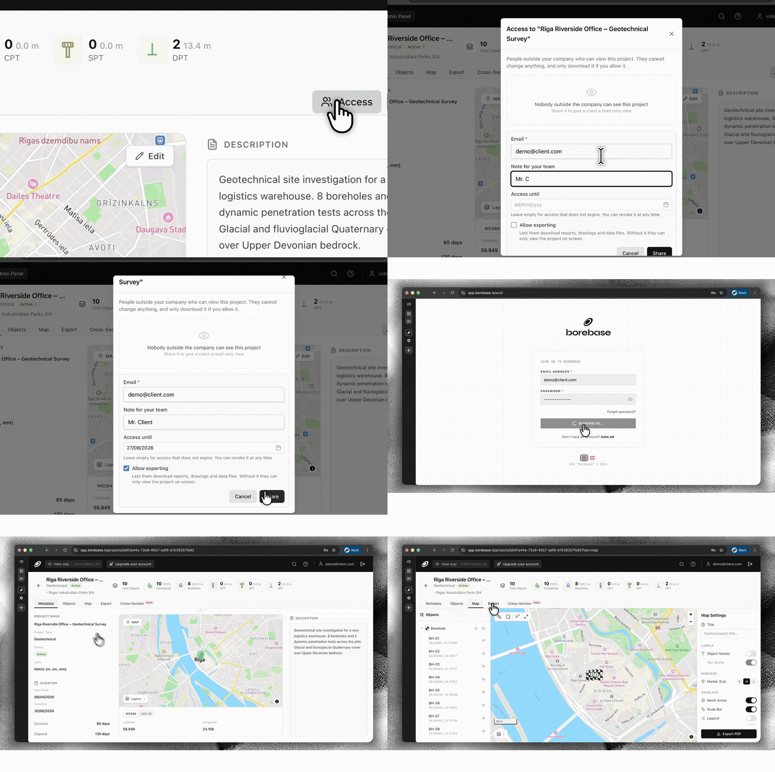
    Give a client, contractor or partner access to one project without adding them to your company workspace. Set an expiry date and decide whether they can export data or keep access view-only.

    Configure secure external project access with a Magic Link
    Set access, expiry and export permissions, then share the same live project.
  • Nytt

    Save stratigraphy as a reusable preset

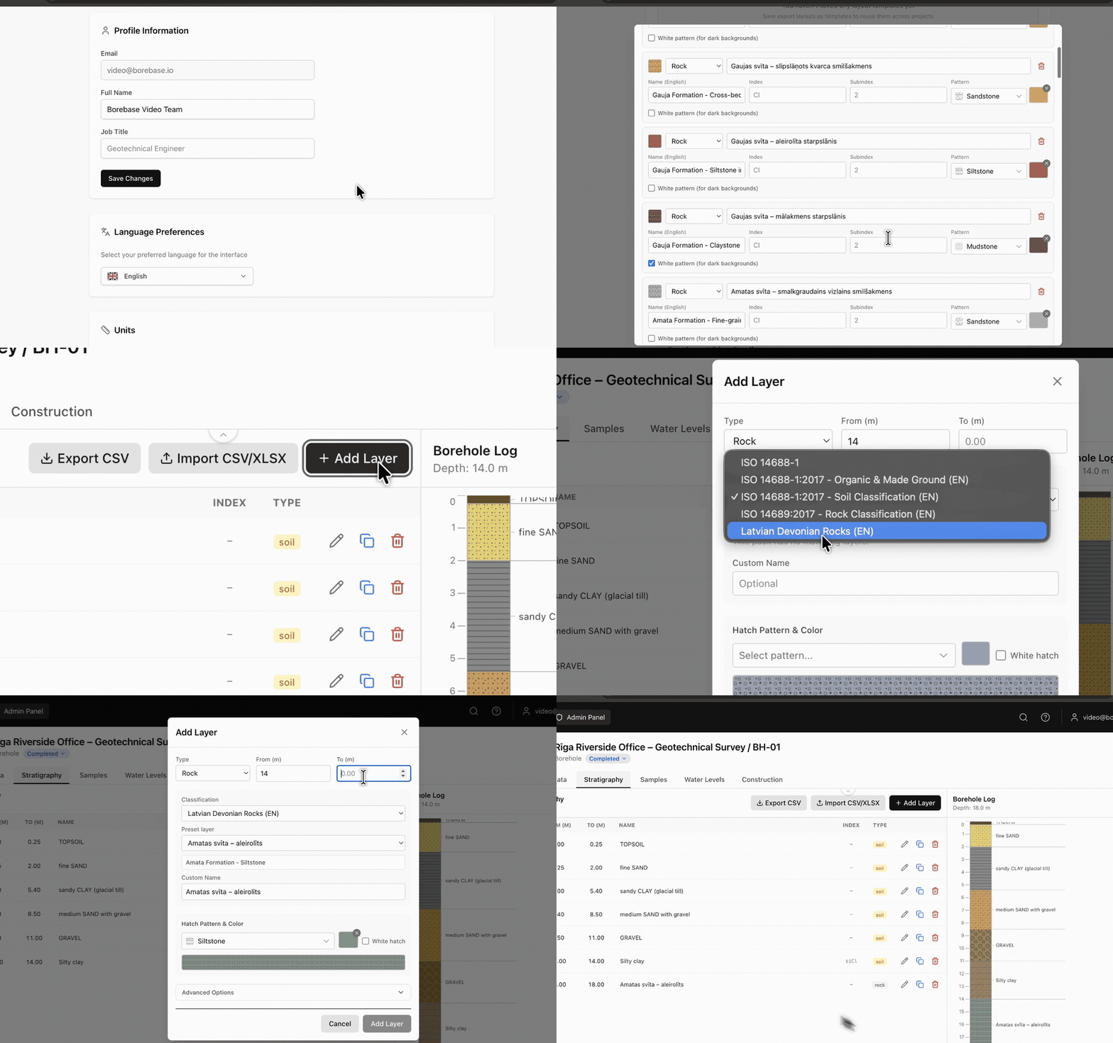
    Build your own stratigraphy preset in Settings and reuse it whenever you enter borehole data. Keep classifications, layer details, hatches and colours consistent across projects.

    Create and reuse a stratigraphy preset while logging a borehole
    Create it once in Settings. Reuse it while logging a borehole.
  • Nytt

    Choose metric or imperial units by project

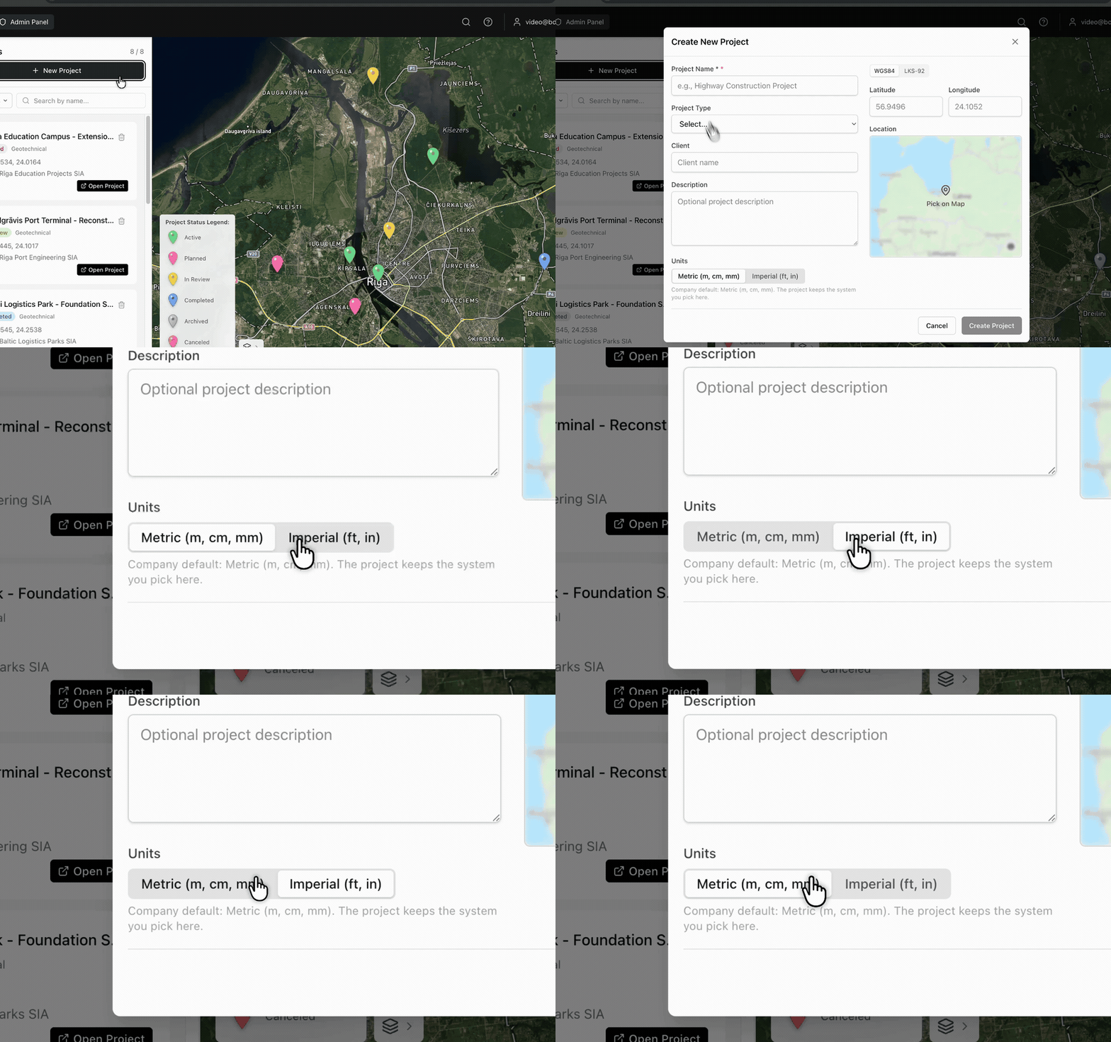
    Select Metric (m, cm, mm) or Imperial (ft, in) when you create a project. Borebase keeps the selected unit system with that project.

    Choose metric or imperial units while creating a project
    The unit system is selected at project creation and stays with the project.
v1.3.0

Faster maps, lighter exports

Static map images are cached, and PDF generation no longer redraws what has not changed.

  • Förbättrat

    Project map tiles load from cache on repeat visits instead of being rendered again.

  • Förbättrat

    Large PDF reports build noticeably faster on projects with many boreholes.

  • Rättat

    Cross-sections with a single object no longer render an empty axis.

Samtycke till kakor

Vi använder viktiga cookies för autentisering och säkerhet. Vi använder inte analys- eller annonscookies; om det någon gång ändras ber vi först om ditt samtycke. Läs mer