101100100001001111010100100000
Nouveautés du produit

LES NOUVEAUTÉS

Les dernières fonctionnalités, améliorations et corrections de Borebase, avec un aperçu détaillé des changements essentiels.

v2.6.0

The geological model

A Model tab with the project's geological model: a stratigraphic column checked against every log, a 3D model built from it, and the model on cross-sections.

  • Nouveau

    The Model tab and the geological model

    A new Model tab holds the project's geological model: set up the stratigraphic column once and assign layers to its units by name across every log. The logs stand on a scheme along a line across the site plan, each beside what the model takes from it. Under it are the questions they raise, such as gaps in the logs and CPTs that disagree with the borehole nearby.

  • Nouveau

    A model in a few steps

    Borebase can suggest the column from the logs, keeping every layer name as a layer of its own or grouping the layers by soil and rock type or by material. It asks only what it cannot decide, and a group opens to show each layer in it, so a layer you read differently can be counted as another group.

  • Nouveau

    The geological model in 3D

    Build the model from the column and each unit becomes a solid body around your boreholes, with its volume, thickness, elevations, colour and hatch beside it. Turn it, stretch it, cut it with a clip box, measure between any two points, pull the units apart and save a picture with a legend. Its ground follows an uploaded terrain model or the relief of the topo plan.

  • Nouveau

    Choose how contacts run between boreholes

    Build settings offer six ways to draw the contacts between boreholes: straight, smooth, cubic, inverse distance, nearest borehole and a trend surface, each with a line on what it does to the model. Ground drawn on a cross-section far above or below the boreholes beside it is left out of the model and named in the build warnings.

  • Nouveau

    The geological model on cross-sections

    A cross-section can show the model cut along its line, under your own correlation, and correlation lines you bend on a section guide the next build. In the 3D view, a click on a side of the model or a face of the clip box saves a cross-section along that cut with the boreholes and CPTs nearby on it, and dragging a contact of the model there bends the next smooth build through that point.

  • Nouveau

    Export the geological model

    Download the model as GLB, OBJ or STL bodies, as LandXML, ESRI ASCII or XYZ surfaces, as 3D faces in a DXF, or as borehole tables for Leapfrog and Datamine.

  • Nouveau

    The first time you sign in after this release, a short slideshow with clips walks you through what 2.5 and 2.6 brought: the project and object overviews, weight soundings and topo plans, drawings on the map, generated cross-sections, geophysics and the geological model in the Model tab.

  • Amélioré

    In Compare boreholes, layers assigned to units of the geological model are joined unit by unit from one borehole to the next, with each unit's top and thickness in the table.

  • Amélioré

    The Cross-Section tab opens on a table of the project's sections beside a preview of the one you pick, its line on the map above its sheet. An open section is laid out like the 3D model: pick another from the toolbar or step through them with the arrows beside it, fold the side panels away or drag them wider, and beside the drawing see only what is drawn on it.

  • Amélioré

    The Map tab is laid out the same way: the layers on the left with an eye on each, the map settings on the right, and Export PDF in the toolbar above the map. A click on the topo plan shows its coordinate and height systems and what can be done with it beside the map.

  • Amélioré

    The Export tab lists the report sheets beside a preview of the one you pick, as the Objects tab lists objects beside the map. An open sheet is laid out like the 3D model too, and another sheet is picked from the toolbar or reached with the arrows beside it.

  • Amélioré

    The Geophysics tab on boreholes, with LAS and CSV import and curves on cross-sections and report sheets, is open to every user.

  • Amélioré

    The Location map on a project's or an object's overview zooms with the mouse wheel, without pressing Edit location first.

  • Amélioré

    The map's PDF export now includes the project's topo plan when it is switched on, drawn as on the map and without the layers and groups you have hidden.

  • Amélioré

    Exporting the map to PDF is faster, and the file is much smaller on the streets, light, dark and outdoors styles.

  • Amélioré

    A weight sounding can be tied to the borehole it was made beside, from the sounding's overview or from the borehole's related tests, as CPT, SPT and DPT tests already can.

  • Corrigé

    Zoomed far out on the project map, object names, cross-section names and the numbers around a weight sounding stay hidden until you are close enough to read them, and the markers shrink to small dots that still show where the site is.

  • Corrigé

    The weight sounding diagram on the Sounding tab scales its half-turn axis to the largest value, so a loose soil fills the width and high counts stay apart.
v2.5.0

Weight sounding and topo plans, imported from 3D-Win and CAD

  • Nouveau

    Weight sounding

    Weight sounding (painokairaus, ISO 22476-10) is a new object type, with its intervals and diagram side by side on the Sounding tab and each layer hatched in a pattern you can change. Import a 3D-Win .kr.tdw file and every sounding in it becomes its own object, after you check the soundings found and their coordinate and height systems.

  • Nouveau

    Topo plans on the project map

    Load the surveyor's DWG, DXF or 3D-Win (.tdw) drawing and lay it under the project map, over satellite imagery or on a blank sheet, drawn as the surveyor plotted it. Its layers are grouped into relief, buildings, roads, utilities and the rest, so you can hide what you do not need.

  • Nouveau

    Your own drawings on the project map

    Draw lines, areas, circles and text over the project map, with or without a topo plan, and set their colour, width, dashes and fill; the people on the project see them too. My drawings in the layer list zooms to each one, edits it, hides it or deletes it. Copy lines, areas and texts from the surveyor's drawing into My drawings to change them, and the original stays as it was.

  • Nouveau

    Project overview

    A project now opens on its Overview: the map with every object on it, progress against the plan, what is due next and who is assigned, on one screen. Click an object on the map for its card, then open it or find it in the Objects list. Each card is edited in place, and a new project lists what is left to set up.

  • Nouveau

    Object overview

    Every borehole and test opens on an Overview built the same way: where it stands among the other objects, its depth and dates against plan, its key figures, its technical details and what it is tied to, each edited in place. A borehole's CPT, SPT and DPT tests can now be tied to it from the borehole itself, as well as from each test.

  • Nouveau

    Geophysics curves

    Import borehole geophysics from LAS or CSV, process readings and compare several curves on a shared depth axis. Add a geophysical curve to a borehole on a cross-section and keep its color in report sheets, PDF and DXF exports.

    Scroll through survey curves, then choose the curve and line color displayed beside a borehole on a cross-section.
  • Nouveau

    Borebase suggests the coordinate system from the numbers in the drawing and shows on a small map whether your boreholes fall inside it before you save. In Files, a DWG, a 3D-Win drawing or a soundings file can be looked over before you import it. A 3D-Win code file in the same folder supplies the surveyor's symbols, line types and pens.

  • Nouveau

    The spot heights in a topo plan become a ground surface you can check, leaving out any point that is clearly off. Cross-sections draw the ground along that surface between boreholes, with your own surface points taking priority. In the 3D model's Build settings, Use topo plan relief makes it the model's ground, with no DEM to upload.

  • Nouveau

    Where a borehole's logged collar elevation differs from the topo plan's surface by more than 0.3 m, its location card shows both and lets you take the surface value with one click.

  • Nouveau

    Over a topo plan, weight soundings are drawn as on a Finnish ground investigation plan: point number, collar elevation, depth, bottom elevation and the mark of how the sounding stopped. Cross-section lines are thin, black and lettered at their ends unless you styled them. An imported 3D-Win soundings file is kept in the project's Files and can be imported again from there.

  • Nouveau

    Find the boreholes in the surveyor's drawing and make objects of them: the list shows each with the name and collar elevation the drawing gives it, you tick the ones you want and can change their names and types, and each is placed exactly where the surveyor drew it. A borehole you already have there is marked, and its symbol in the drawing gives way to your object.

  • Nouveau

    Download the topo plan as a DXF from the map's layer list and open it in AutoCAD, BricsCAD or QGIS: the surveyor's drawing in its own coordinates, 3D-Win drawings included, with the layers you hid on the map switched off, and My drawings and the project's objects on layers of their own.

  • Nouveau

    When a drawing's layers are not sorted into groups, as on an architect's site plan, Group by name puts layers whose names start alike together in one click. Rename a group, undo it or build your own, and each group switches on and off as one on the map. Layers of a 3D-Win drawing are grouped by their codes.

  • Nouveau

    The project overview shows what changed lately and who changed it, for everyone on the project, whether or not they follow it.

  • Nouveau

    Weight soundings can now go on export sheets: the PA diagram with its values if you want them, half-turns and load as lines, a hatched soil column, and the soil in ISO, as logged or USCS with a dashed line across the sheet at each new layer. Batch export makes one sheet for every weight sounding in the project, as PDF or DXF.

  • Nouveau

    Weight soundings can be drawn on cross-sections and compared with boreholes and CPTs: their soil layers in the hatches picked for them, with half-turns or load beside them, on screen and in the DXF of the section.

  • Nouveau

    The cross-section editor can draw a first version of the section for you: Generate section offers four presets for the usual cases, with every setting under Advanced. Boreholes, CPTs and weight soundings are joined and the bands you already drew are kept. Afterwards it lists what you may want to take off again, ready to go in one click.

  • Nouveau

    An eraser in the cross-section toolbar removes a band, pinch-out, lens or fault with one click, and every element in the side panel has its own delete button.

  • Amélioré

    Project and object pages have one slim header row: the name and its status beside the tabs, and on an object page the project it belongs to in front of its name. The object counts that sat in the project header are on the Overview's Objects card now, where each still opens the list filtered to what it counts.

  • Amélioré

    The size of object markers on the project map is set with a slider, and the exported map PDF follows it.

  • Amélioré

    Right-click any row in the map's layer list, an object, a group, a cross-section, a measurement, a layer of the topo plan or one of your drawings, and the map zooms to it, framed to its own size.

  • Amélioré

    Text on export sheets can now be set up to 20 pt: layer names, sample labels, construction notes and the weight sounding soil column.

  • Amélioré

    Boreholes, SPT and dynamic penetration tests have new icons: a tricone bit, a drop hammer over its sampler, and a blow landing on the rod. Each type is now easier to tell apart at a glance in object lists, filters and the project header.

  • Amélioré

    ETRS-TM35FIN and ETRS-GK25, Finland's national coordinate system and the one Helsinki, Espoo and Vantaa survey in, are now among the recommended coordinate systems.

  • Amélioré

    Coordinates in a projected system are now entered and shown east first, then north, as surveyors write them, when you create a project or a borehole and on the location maps. A new borehole also opens in the coordinate system its project was recorded in.

  • Amélioré

    Cross-sections have a new Column over the hatch setting next to the column width. Untick it to draw the hatch of the layers between the boreholes on top of the logged columns; the layer names and depths stay on top either way.

  • Amélioré

    In the canvas view of the cross-section editor the lists of sections and objects now start folded, leaving the left panel to the elements of the section you are drawing.

  • Amélioré

    A band that joins several layers of one borehole is drawn in the hatch of the thickest of them, so the fill under a thin asphalt layer keeps its own hatch.

  • Amélioré

    A pinch-out of a layer that starts at the ground and ends on the ground follows the ground line on screen, in the PDF and in the DXF.

  • Amélioré

    On a cross-section, CPT layers that follow one another can now be joined into one band, also where the CPT's layers start a centimetre or two below the previous one.

  • Amélioré

    The cross-section editor's Map and Canvas switch now sits in the toolbar. On the map, the right column shows how long the section line is and which objects stand near it, and objects can be found by name and filtered by type before you add them.

  • Amélioré

    Moving between a project's tabs switches in place, and only opening a project slides in.

  • Amélioré

    The location map on an object's overview shows only that object.

  • Corrigé

    Cross-sections drawn before August save and rename normally, with every band left as it was.

  • Corrigé

    The tests listed on a borehole show whether each is planned, active, completed or cancelled.

  • Corrigé

    In fullscreen, the cross-section editor's toolbar fits on the screen with every tool and the button that leaves fullscreen.

  • Corrigé

    The project card on the dashboard map lists every kind of object the project holds, each with its own count: boreholes, CPT, SPT, dynamic probing and weight soundings.

v2.4.0

Borehole imports, three hatch libraries and faster batch PDF

  • Nouveau

    Import samples, water levels and construction

    The Samples, Water Levels and Construction tabs of a borehole can now be filled from a CSV or Excel file, with the columns matched for you as in the other import wizards. Rows already in the table are skipped, so importing the same file again adds nothing.

  • Nouveau

    Three hatch libraries

    A layer's hatch can now come from three libraries: the Borebase patterns, the USCS group symbols with every dual symbol, and the USGS lithology patterns used by Stratapy, grouped by soil and rock type and searchable by name. Layers classified by USCS are drawn with their own group symbol, in the log, in sections and in PDF and DXF exports.

  • Nouveau

    On the Stratigraphy tab, open a layer's picker and click a core photo to give the layer the colour of the soil in it.

  • Nouveau

    The first time you sign in after this release, a short slideshow walks you through what 2.3 and 2.4 brought, and the release notification in the bell opens it again.

  • Amélioré

    Layers, CPT layers, preset packs and geomodel units now share one picker that sets the colour, dark or white hatch lines, the pattern and its scale in one place, with the patterns you used last at the top.

  • Amélioré

    The stratigraphy import asks only for the columns Borebase uses, and leaves a description column in the file aside.

  • Amélioré

    The map style you pick, such as satellite or outdoors, is remembered and used on every map in Borebase, also after a reload.

  • Amélioré

    In the Files tab, drag files and folders onto another folder to move them, or cut them with Ctrl+X and paste with Ctrl+V. Files or a screenshot copied on your computer paste straight into the open folder.

  • Amélioré

    A ZIP uploaded to the Files tab can be unpacked on the way, its folders kept; you are always asked first. A folder dragged in from your computer is uploaded with all its folders, the empty ones too. A new folder appears in place with its name ready to type, and photos open full screen while you assign them to objects before uploading.

  • Amélioré

    Every person in your company now adds 2 GB of space for project files, and a single file, such as a drilling video, can be up to 1.5 GB. When the files fill 80% of that space, the company's admins are told in the app and by email, and the Files tab offers a ready email to ask us for more.

  • Amélioré

    While a batch export is being turned into files on the server, the export window shows how many files are ready and says that the server is still converting.

  • Amélioré

    Batch PDF exports finish sooner, and logs that run over several pages are about three times faster.

  • Amélioré

    Opening a project from the list, going back to it and moving between a project's tabs slide into place.

  • Amélioré

    The cross-section editor stays steady while you edit: a note that object data is loading appears over the drawing.

  • Corrigé

    The location of an object or a new project opens in the coordinate system it was entered or imported in, for example LKS-92.

  • Corrigé

    A data file saved as .xls or .xlsx that is really text, as some loggers export them, is imported as text in every import wizard, so decimal commas and day-first dates are read correctly. An empty spreadsheet is refused on upload, like an empty CSV.

  • Corrigé

    Completed and cancelled objects and closed projects show no days remaining to their deadline and do not count as overdue.

  • Corrigé

    Geophysics surveys belong to a borehole, so Geophysics is not an object type of its own. Objects created as Geophysics earlier are now boreholes, with their surveys kept.

  • Corrigé

    Double-clicking an object in the Objects list opens it without selecting the text of the row.

  • Corrigé

    A stratigraphy import takes very long layer names: a name over 255 characters is shortened, the preview warns about it first, and if any layers cannot be saved you are told how many.

  • Corrigé

    When two people work on the same cross-section and someone saved it after you opened it, you are asked whether to keep your version or load theirs.

v2.3.0

Notifications, project files and boreholes side by side

A notification centre with reminders, a Files tab that opens reports and drawings in the browser, export sheets as DXF, and boreholes compared side by side.

  • Nouveau

    Your notification centre

    The bell in the header opens your notification history. Mark messages as read, archive them and choose in Settings how each kind reaches you. Every new unread notification shows a toast when the centre is closed, while important and critical notices are also marked in colour.

  • Nouveau

    Assignments and deadline reminders

    You are told when a colleague assigns you to a task or removes you from it. Project and task deadlines send reminders a week and a day ahead, and once more when they are overdue.

  • Nouveau

    Follow a project

    Choose a subscription level or your own combination of six event types from the bell in a project's header, with object creation and imports sharing one choice. Status and invitation updates arrive separately, while other selected changes are grouped into five-minute summaries. Guests can follow shared projects too.

    Choose a level or adjust the event checkboxes to make a Custom subscription. Demonstration data only.
  • Nouveau

    Open items in the header

    Objects, export sheets and cross-sections you open get a tab across the top, so going back to one is a single click. Up to eight stay open, and opening a ninth closes the one you have not looked at for longest.

  • Nouveau

    Talk to the Borebase team from the Help menu

    Report a problem, ask a question or suggest a feature with Send feedback in the Help menu. Attach screenshots, paste one straight from the clipboard or add a short screen recording, and your message goes directly to our team.

  • Nouveau

    Keep your main projects at the top

    Click the star on a project card to pin it. Pinned projects stay at the top of your own project list on any computer you sign in from, and your colleagues' lists do not change.

  • Nouveau

    Project files and a file viewer

    Every project now has a Files tab: upload reports, drawings and photos, keep them in folders and assign them to the boreholes, CPTs and other objects they belong to. Filter by type or object, group by type, date or name, act on several files at once, and restore anything from the trash for 30 days.

  • Nouveau

    Core photos on the borehole log

    Photos assigned to a borehole now appear under its stratigraphy table, with zoom, contrast and arrows to step through them. Mark a photo as the borehole's stratigraphy with the depths it shows, and a click on the borehole log at those depths opens it. Files uploaded to a project with objects can be assigned and marked right away.

  • Nouveau

    Export sheets as DXF

    The export editor saves a sheet as a DXF drawing for AutoCAD and other CAD programs, for one object or a whole batch. It is the same sheet as the PDF, in millimetres, with each column on its own layer, soil and rock patterns as hatches you can edit, and a layout for every page.

  • Nouveau

    Compare boreholes side by side

    Tick objects and press Compare, or press Compare with nearest on a borehole. The logs stand side by side, aligned by elevation or depth, with layers of the same name joined and a table of each layer's top and thickness. Add a map and true distances, then print on A4 or A3 or download as PNG, SVG or CSV.

  • Nouveau

    A borehole's log on the project map

    Click a point on the Objects map and a card shows its elevation, depth, latest water level and a small log, with Compare with nearest and Open.

  • Nouveau

    USCS soil classification

    Soil layers can be classified by USCS (ASTM D2487) as well as by ISO 14688-1 and your own preset packs. Pick a group such as CL or SP-SM, or enter the sieve results, Cu, Cc and Atterberg limits and follow the D2487 flowchart step by step to the group, such as "Sandy lean clay with gravel". The layer takes its group name, symbol and hatch, and a new layer opens on the classification you used last.

  • Nouveau

    Export to gINT and AGS4

    The Objects tab exports the project's boreholes and SPTs as a gINT workbook or an AGS4 file, with their layers, samples and SPT blow counts. Depths follow the project's units, coordinates the project's coordinate system, and an SPT driven in a borehole is logged under that borehole.

  • Nouveau

    Administrators are reminded before a trial or academic access ends, when a subscription is cancelled and when a payment fails. Project viewers are reminded before their access ends.

  • Nouveau

    PDFs, DXF drawings with their layers, Word, PowerPoint, Excel and CSV files, photos, videos and text files open right in the browser, with JSON and XML in colour. A file from your own computer can be viewed there without uploading it.

  • Nouveau

    LKS-2020 / Latvia TM (EPSG:10306) is in the coordinate system list.

  • Amélioré

    Archived notifications can be restored or removed for good, and each category has its own icon and colour.

  • Amélioré

    Notification settings let you search the projects you follow, see each subscription level, change its event choices and unsubscribe directly from the list.

  • Amélioré

    With the project header collapsed, the notification, access and edit controls stay within reach on Metadata.

  • Amélioré

    The Admin Panel has moved into the menu under your email, in the top right corner.

  • Amélioré

    On the stratigraphy tab, drag the borders to share the room between the layer table, the photos and the borehole log, and the tab stays that way next time. The borehole log zooms in with the mouse wheel, layer names use the whole width of the log, and the name of a thin top layer shows in full.

  • Amélioré

    The graphs of CPT, SPT and dynamic penetration tests zoom in on depth with the mouse wheel as well, every graph at once, and scroll together so their depths stay level.

  • Amélioré

    In the export editor, click a parameter's name in a column header to pick it: it is marked in the object list and its settings open on the right. Drag the picked name to another column to move it with its settings, take it off the sheet with the cross beside it, or click anywhere else to let go of it.

  • Amélioré

    A stratigraphy column in the export can draw its hatching denser or coarser than each layer's own scale, and can go black and white for printing: every layer white, told apart by its hatch alone.

  • Amélioré

    The counters at the top of a project show only the kinds of objects it has: a project of boreholes alone shows its total and its boreholes, and an empty project shows a total of zero.

  • Amélioré

    The counters in the project header look like buttons, show which one filters the list, and a second click shows the whole list again.

  • Amélioré

    The construction elements of a borehole open as a tidy form: every field has its label and unit and is plainly something to fill in. Pointing at an element or a soil layer on the construction schematic shows what it is, its depths and everything recorded about it.

  • Amélioré

    The annotations beside a borehole construction in an export have their own font size setting. Labels of elements close together stay apart and inside the hole, and a 0.5 mm screen slot is printed as 0.5 mm.

  • Amélioré

    The Map tab shows the project's cross-sections as lines through their boreholes, each switched on or off in the layer list and given its own colour, width and dashes. Their names can be written along the line or level, with or without a white buffer, and the exported map shows them exactly as the screen does.

  • Amélioré

    The cross-section you have open stays open when you reload the page, and a link to it opens the same section for a colleague.

  • Corrigé

    In the last week of a month, a task due early next month appears once on the plan board.

  • Corrigé

    A layer added from a preset pack opens on its pack and preset layer when you edit it, and saves without having to be classified again.

  • Corrigé

    A value you clear in a layer's details, such as a liquid limit or a grain size percentage, stays cleared after saving.

  • Corrigé

    SPT data exports label the Young's modulus columns in MPa with two decimals, matching the values in the file. Exports made before this release label them kPa and round to whole numbers.

  • Corrigé

    Dynamic probing exports name the penetration column per blow, as m/blow or ft/blow. Exports made before this release name it in plain metres or feet.

  • Corrigé

    Soil and rock patterns in cross-sections exported to DXF open in CAD with every stroke in place, and those drawings open in the file viewer.

  • Corrigé

    The borehole log of a hole shallower than 10 m fills its column.

  • Corrigé

    Picking an item in the export editor while the Overall settings are open shows its settings at once, and long settings scroll with a single bar.

  • Corrigé

    An object's samples download as an Excel workbook.

v2.2.4

A demo project to explore

  • Nouveau

    Accounts prepared by the Borebase team include a populated demo project with investigation locations, measurements, cross-sections and report layouts, ready to explore after signing in.

  • Corrigé

    After a renewal or a payment, the Subscription page shows the current status and the end of the current billing period.

v2.2.3

Borebase in Spanish and French

  • Nouveau

    Spanish and French

    Use Borebase in Spanish or French, from signing in to preparing reports, and choose either language for your account or for a single export. The website and the technical guides are translated too.

  • Amélioré

    Estonian and Finnish terminology was reviewed across the app, the website and the guides, and import dialogs, export labels and plan groups follow the selected language.

  • Amélioré

    The website has a compact language menu, and Spanish and French pages fit smaller screens.

  • Corrigé

    Dates in exported drawings print in full.

v2.2.2

GeoJSON export and new pricing

  • Nouveau

    GeoJSON export

    Export project objects as GeoJSON from the Objects tab, ready for QGIS or ArcGIS. Each object becomes a point with its name, type, status, elevation and depth.

  • Amélioré

    Updated pricing

    New subscriptions cost €79 per user a month or €790 a year, the same on the pricing page and at checkout. Existing subscriptions keep their current price.

  • Amélioré

    Duplicating an object copies all of it, including the borehole construction, every layer type and SPT and dynamic probing data.

  • Amélioré

    Borehole and project pages load only the tab you open, so they appear faster on a slow connection.

  • Corrigé

    CPT, SPT and DP exports, recalculation and stratigraphy generation cover tests of any length, including those over 20,000 readings.

  • Corrigé

    Batch export draws geophysics graphs and CPT layer colours the same as a single export.

  • Corrigé

    A CPT, SPT or DP test linked to a borehole while it is being created keeps that link.

  • Corrigé

    On a project in feet, the depth scales beside the stratigraphy log and on the CPT stratigraphy tab show feet.

  • Corrigé

    The dynamic probing export writes Yes or No in the Refusal column.

  • Corrigé

    Geophysics surveys show their type, unit and colour.

  • Corrigé

    Object markers show on project and cross-section maps in every browser, Firefox included.

  • Corrigé

    Status change and map export messages appear in your language, and a tab left open keeps receiving live updates.

v2.2.1

Faster pages and interpreted cross-sections

  • Nouveau

    Geological units on cross-sections

    Connect an interval to a group of intervals as a named geological unit without changing the borehole logs, show a lateral transition with a straight or broken contact, and add a pinch-out from a selected layer.

  • Nouveau

    Water levels across a cross-section

    Connect water levels between boreholes and drag the curve between them. Measured levels stay fixed, and the curve goes into PDF and DXF exports.

  • Nouveau

    Task descriptions and assignees

    A task on the plan can carry a description and several assignees, and a person filter works on the board and the timeline.

  • Amélioré

    Noticeably faster

    Pages and projects open several times faster, the first visit downloads much less, and large CPT and SPT imports finish in a fraction of the time. The app stays responsive for everyone while a large export runs.

  • Amélioré

    CPT stratigraphy shows layer averages from the current measurements, including layers you drew by hand, and CSV and Excel exports use the same values.

  • Amélioré

    Boreholes and dynamic probing have clearer icons across the app and on exported maps.

  • Amélioré

    Project and object headers collapse into one compact row with the name and all tabs.

  • Corrigé

    Signing in always takes you straight into the app.

  • Corrigé

    Guests can find the projects shared with them in the search box.

  • Corrigé

    Cross-section surfaces keep their shape at any scale and column width, and PDF exports leave out selection outlines and editing handles.

  • Corrigé

    The plan board fills the window, and the timeline scale leaves task details clear.

v2.2.0

A plan for the whole project

  • Nouveau

    The Plan tab

    Every project has a Plan tab: all of its work on one schedule, as a timeline or as a board grouped by deadline. Click a bar or a card to change its dates and status, or drag it to move them.

    Drag a bar to move its dates; the change is saved at once and can be undone for a few seconds.
  • Nouveau

    Work that is not a borehole

    Mobilisation, a lab batch or the report can go on the plan with its own deadline and a progress percentage.

  • Nouveau

    The project at a glance

    Project details open with metres drilled against planned, objects closed against ordered and how much of the schedule has gone, and say which of the three is behind.

  • Amélioré

    The counters in the project header open the object list filtered to what they count.

  • Amélioré

    An Elements list beside the cross-section names every correlation, pinch-out, lens, fault and surface point. Click one to select it on the drawing.

  • Amélioré

    The cross-section toolbar floats over the drawing to leave it more room, and cross-sections are out of Alpha.

  • Amélioré

    A cross-section DXF opens on the same sheet as the PDF, with hatches and white fills that look as they do in the PDF, and large sections stay small enough to open. A long legend continues onto further pages.

  • Amélioré

    Object names on a cross-section can be shown or hidden for each object type.

  • Amélioré

    A custom chart on the CPT Advanced tab can run either axis from maximum to minimum, for example depth downwards.

  • Amélioré

    Deleting your account now sits behind a High risk zone that you open first.

  • Corrigé

    The borehole construction schematic draws screens, filter packs and grout at the right size, on screen and in the PDF.

  • Corrigé

    The object list keeps its order after you edit an object, and a planned depth stays after a reload.

v2.1.0

Your data, planned depths and a faster app

  • Nouveau

    Download or delete your account

    Settings has a Your data section: download everything we store about your account, or delete the account for good. Projects and reports stay with the company that owns them.

  • Nouveau

    Planned depth

    A borehole, CPT, SPT or DP point can carry the depth it was ordered to reach, next to the depth actually reached.

  • Amélioré

    Opening a project or an object keeps the window in place, and heavy tabs respond the moment you click them.

  • Amélioré

    The company logo appears in the cross-section DXF export, as it does in the PDF.

  • Amélioré

    Every input field in the app has one look, in the same three sizes.

  • Corrigé

    The guided tutorial moves on as soon as you press Next, and going back a step, the import dialog, the language picker and the pattern list all behave as expected.

v2.0.0

Deeper interpretation, and five new languages

Advanced CPT interpretation with a technical PDF report, geological interpretation on cross-sections, a guided tutorial on demo data, clearer imports, and Borebase in five more languages.

  • Nouveau

    Advanced CPT interpretation

    A new Advanced tab on a CPT plots any two parameters against each other, with depth filtering, linear or logarithmic scales and colouring by depth. It classifies by Robertson 1990 and 2009 SBTn, Robertson 2016, Qt-Bq and Qtn-U2, and exports a landscape A4 technical report.

  • Nouveau

    Geological interpretation on cross-sections

    Draw correlations, lenses, pinch-outs and faults on a cross-section and edit the surfaces directly. The interpretation is saved with the project, so everyone in the company opens the same drawing.

  • Nouveau

    Five more languages

    The app and the website are available in Estonian, Lithuanian, Finnish, Swedish and Norwegian, alongside English and Latvian. Exports and reports follow the language you choose.

  • Nouveau

    A guided tutorial on demo data

    New users can walk through a complete investigation on a demo project: place objects on the map, log stratigraphy, record samples and lay out the PDF. Your real projects are never touched, and the tutorial can be started again from Settings.

  • Nouveau

    Hatch scale per layer

    Every hatch picker has a scale, from a tenth to ten times the standard size. The layer keeps it wherever it is drawn: the log, the cross-section, the legend and the PDF and DXF exports.

  • Nouveau

    Match layer colours across a project

    A brush next to Regenerate Layers proposes, for every soil layer, the colour already used for the same material elsewhere in the project. Preview it, apply what you want and undo the whole batch. On the CPT stratigraphy tab it leaves colours you chose by hand alone.

  • Amélioré

    Cross-section exports with a legend, in colour or black and white

    PDF and DXF exports end with an A4 legend of the hatches actually used, and one switch exports them in greys that stay readable on an office printer. The base of made ground and the top of bedrock are drawn as heavier lines.

  • Amélioré

    Imports that explain themselves

    The object import shows row numbers, problems, detected types and duplicates before anything is saved, and accepts .xls and .ods files. CPT import recognises Pagani files, and SPT and DPT imports read the files rigs actually produce.

  • Amélioré

    Impossible layer parameters, such as a 660 % clay fraction, are refused in the form with the allowed range shown.

  • Amélioré

    The privacy policy states what personal data we process, why, who receives it and for how long, and borebase.io sets no analytics or advertising cookies.

  • Corrigé

    Young's modulus on a CPT

    The drained Young's modulus is 0.8 of the constrained modulus M, following Robertson (2009), and stays below it. Interpretations saved before this release keep their earlier values until you re-run them.

  • Corrigé

    A failed or empty import leaves existing CPT, SPT and DPT measurements untouched.

  • Corrigé

    Every coordinate box opens in the system chosen in Settings, switching systems returns exactly the numbers you typed, and a system picked in one form applies to that form alone.

  • Corrigé

    Cross-sections draw cleanly through deep depressions and large faults, long labels wrap in the DXF, and overlapping objects can each be picked from the map.

  • Corrigé

    The terms and privacy links on the sign-up form open correctly, and the product-updates checkbox starts unticked.

v1.4.0

Safer sharing, faster data entry

Share live projects with external collaborators, reuse your stratigraphy setup and create projects in metric or imperial units.

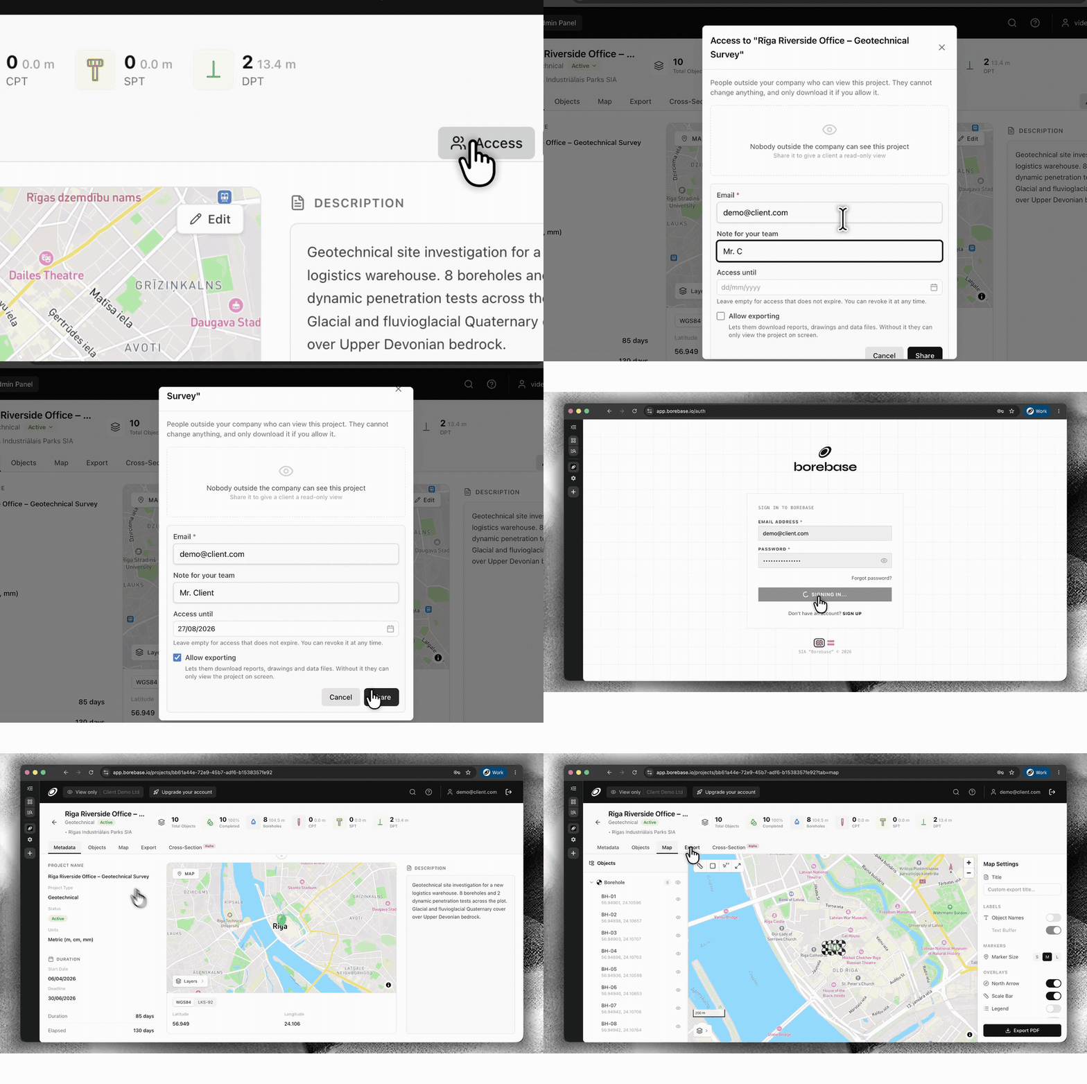
  • Nouveau

    Share projects securely with Magic Links

    Give a client, contractor or partner access to one project without adding them to your company workspace. Set an expiry date and decide whether they can export data or keep access view-only.

    Configure secure external project access with a Magic Link
    Set access, expiry and export permissions, then share the same live project.
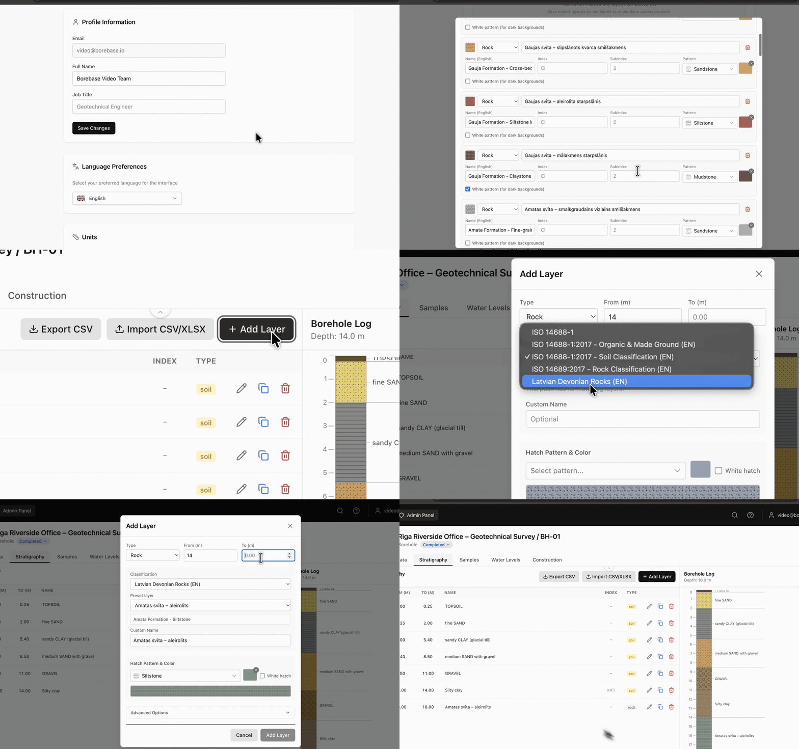
  • Nouveau

    Save stratigraphy as a reusable preset

    Build your own stratigraphy preset in Settings and reuse it whenever you enter borehole data. Keep classifications, layer details, hatches and colours consistent across projects.

    Create and reuse a stratigraphy preset while logging a borehole
    Create it once in Settings. Reuse it while logging a borehole.
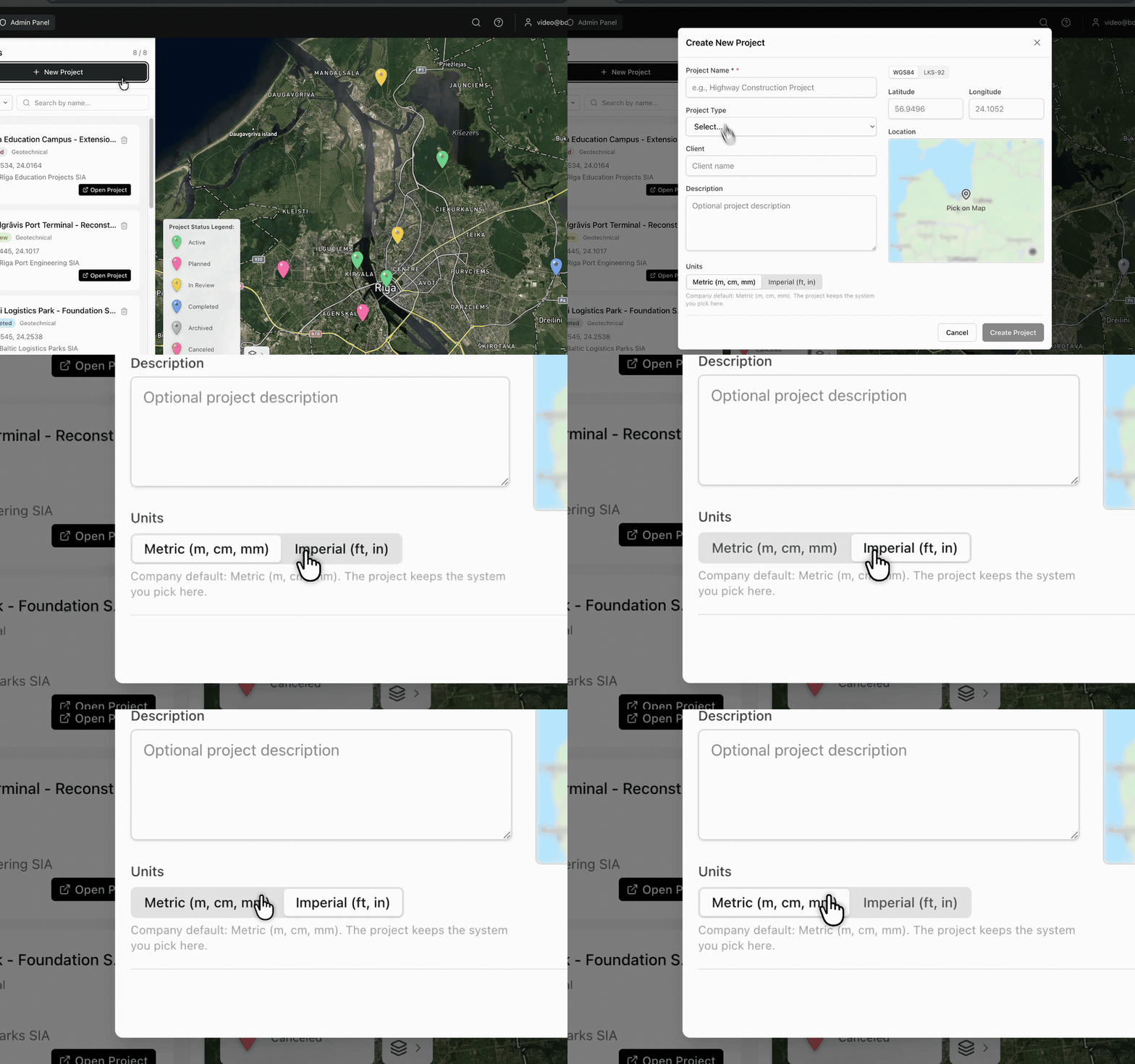
  • Nouveau

    Choose metric or imperial units by project

    Select Metric (m, cm, mm) or Imperial (ft, in) when you create a project. Borebase keeps the selected unit system with that project.

    Choose metric or imperial units while creating a project
    The unit system is selected at project creation and stays with the project.
v1.3.0

Faster maps, lighter exports

  • Amélioré

    Project maps load faster on repeat visits.

  • Amélioré

    Large PDF reports build noticeably faster on projects with many boreholes.

  • Corrigé

    Cross-sections with a single object draw without an empty axis.

Consentement aux cookies

Nous utilisons des cookies essentiels pour l’authentification et la sécurité. Nous n’utilisons aucun cookie d’analyse ou de publicité. Si cela change, nous vous demanderons d’abord votre consentement. En savoir plus